Reviewed-on: #19 |
||
|---|---|---|
| .settings | ||
| src | ||
| .classpath | ||
| .gitignore | ||
| .project | ||
| CHANGELOG.md | ||
| LICENSE.md | ||
| README.md | ||
| descriptor.xml | ||
| pom.xml | ||
| profile.xml | ||
README.md
GeoPortal Data Viewer App
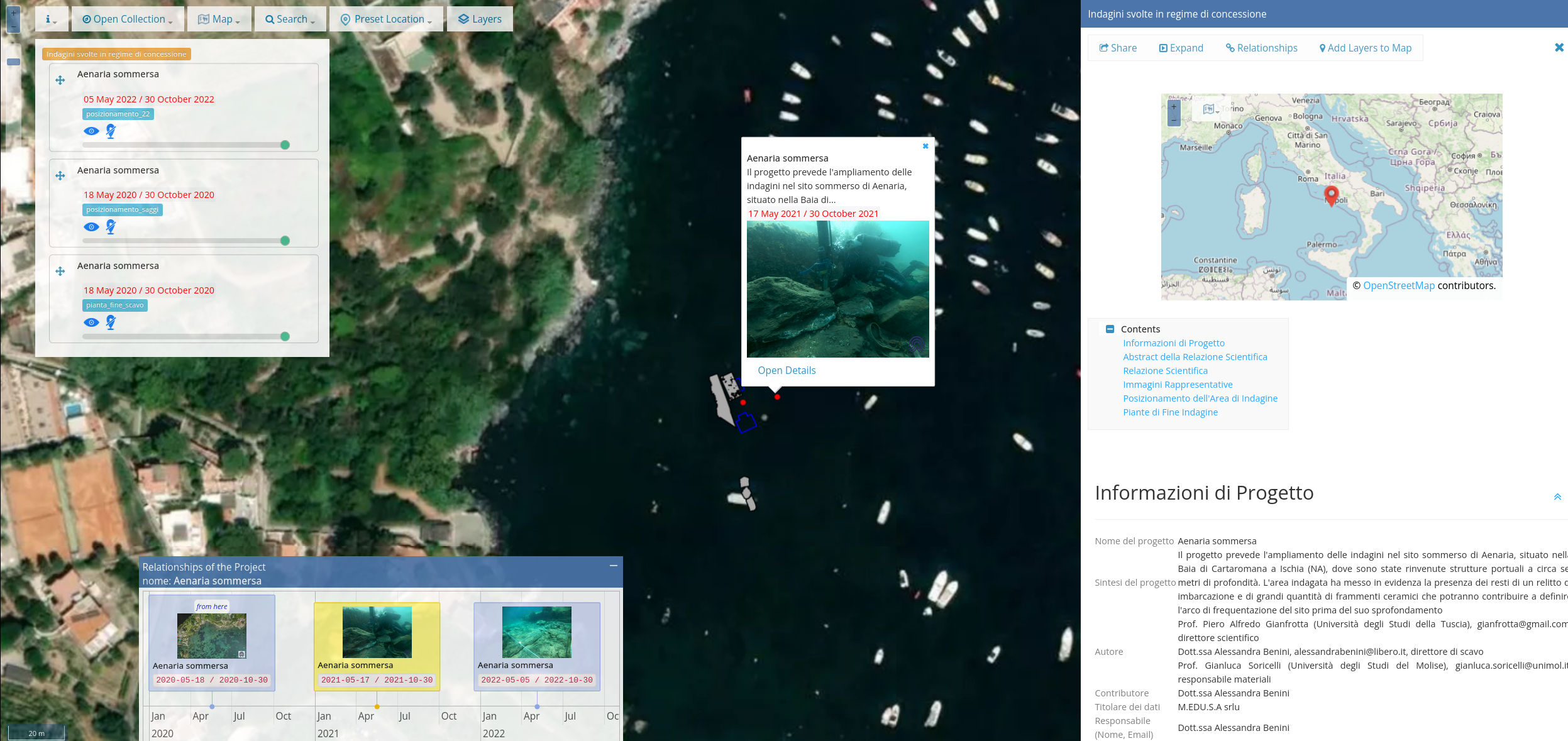
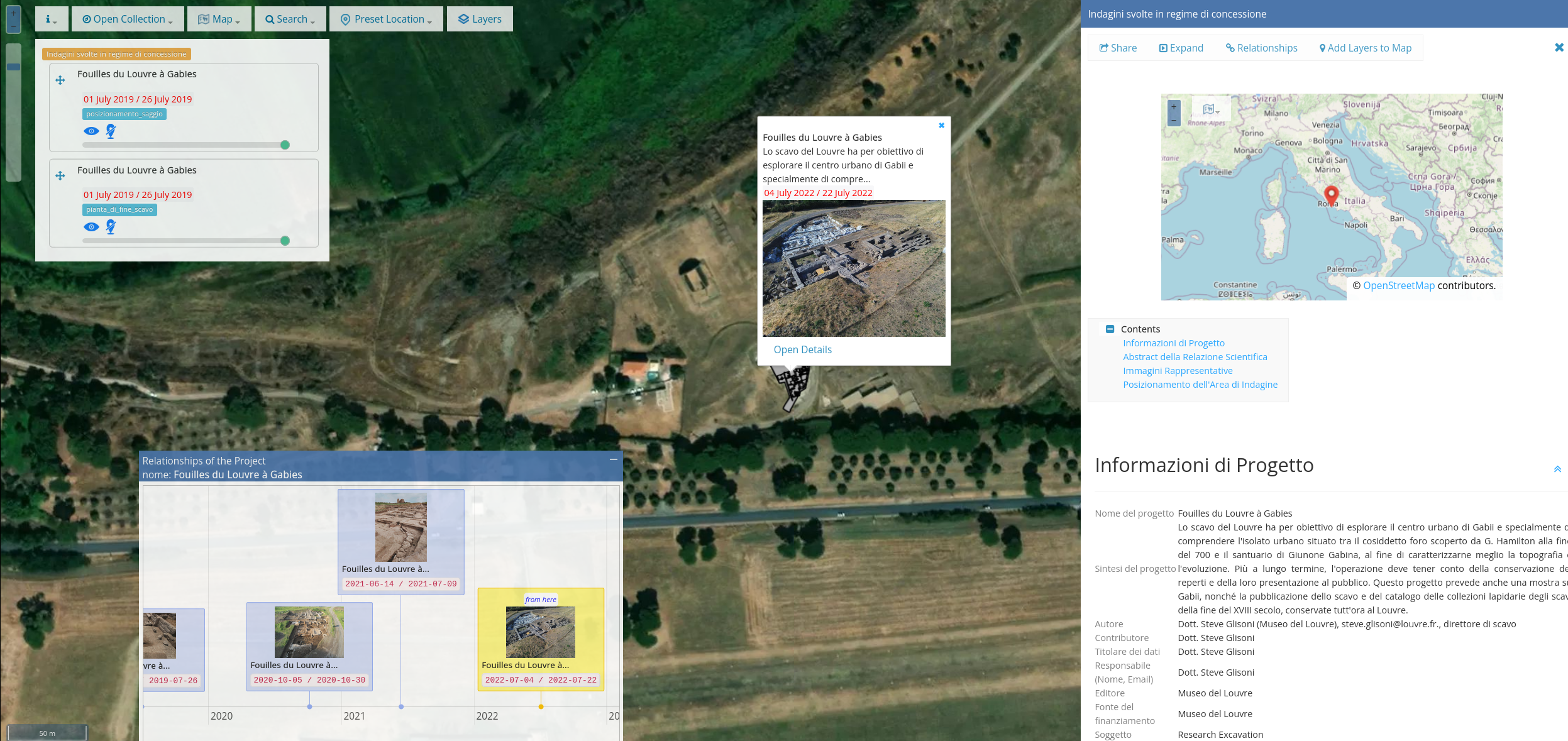
The "Geoportal data-viewer" technology allows users to access and search for spatio-temporal documents through a web GIS which allows them to: (i) navigate and select the projects published in the system by "geographical map" (spatial dimension) , (ii) navigate and select the relationships between projects (evolution of over time) via "timeline" (temporal dimension), (iii) view metadata and resources (images, layers, etc. .) of documents via the "project view detail", (iv) export a view of the map with the layer of interest or add the layers of a project to the main map, (v) manage the order and overlapping of the layers, (vi) execute spatial queries on the layers and view the results, (vii) search through metadata or temporal dimension queries for the projects of interest, (vii) apply spatial filters for cross-layer.
Built With
Uses
- GWT v.2.10.0. GWT is licensed under Apache License 2.0
- GWT-Bootstrap v.2.3.2.0. GWT-Bootstrap is licensed under Apache License 2.0
- GWT-OpenLayers 3+ v.8.5.0-gwt2_9. GWT-OL3
- OpenLayers v.6.x OpenLayers is licensed under BSD 2-Clause "Simplified"
- NanoGallery v2.X NanoGallery2 is licensed under GNU General Public License "gplv3"
- Vis-Timeline v7.x VisTimeline is licensed under Apache License 2.0 and MIT
- Handlebarsjs v4.x Handlebarsjs is licensed under MIT
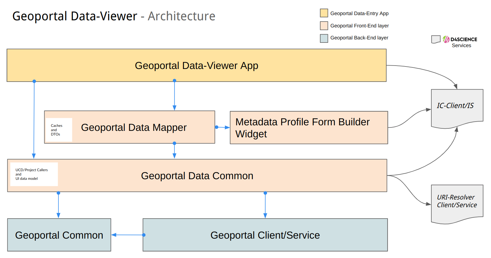
Architecture
Showcase
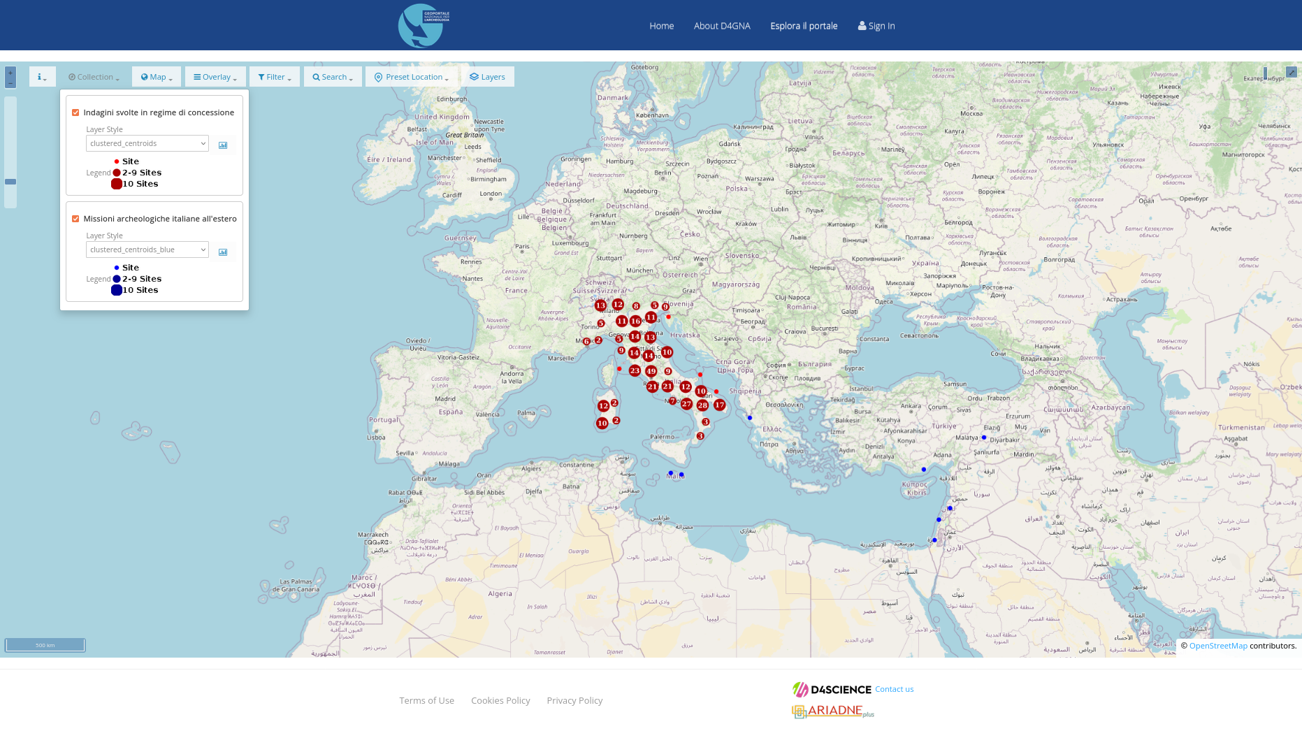
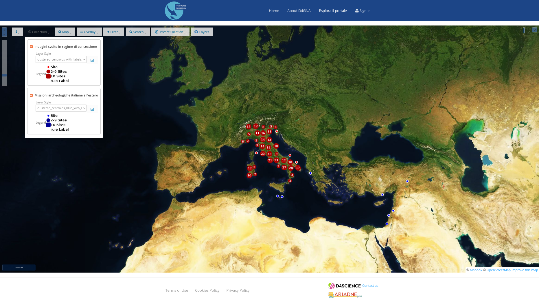
D4GNA instance of Geoportal D4Science
see at Dataset per il Geoportale Nazionale per l’Archeologia (D4GNA)
D4GNA Viewer - OSM
D4GNA Viewer - MapBox
D4GNA Viewer - Discovering...
Documentation
Geoportal Service Documentation is available at gCube CMS Suite
User Guide (DRAFT ITA) is available at Guida al DataViewer D4GNA (DRAFT-ITA)
Change log
See the Releases
Authors
- Francesco Mangiacrapa (ORCID) Computer Scientist at ISTI-CNR Infrascience Group
License
This project is licensed under the EUPL V.1.1 License - see the LICENSE.md file for details.
About the gCube Framework
This software is part of the gCubeFramework: an open-source software toolkit used for building and operating Hybrid Data Infrastructures enabling the dynamic deployment of Virtual Research Environments by favouring the realisation of reuse oriented policies.
The projects leading to this software have received funding from a series of European Union programmes including:
- the Sixth Framework Programme for Research and Technological Development
- DILIGENT (grant no. 004260).
- the Seventh Framework Programme for research, technological development and demonstration
- D4Science (grant no. 212488);
- D4Science-II (grant no.239019);
- ENVRI (grant no. 283465);
- EUBrazilOpenBio (grant no. 288754);
- iMarine(grant no. 283644).
- the H2020 research and innovation programme
- BlueBRIDGE (grant no. 675680);
- EGIEngage (grant no. 654142);
- ENVRIplus (grant no. 654182);
- PARTHENOS (grant no. 654119);
- SoBigData (grant no. 654024);
- DESIRA (grant no. 818194);
- ARIADNEplus (grant no. 823914);
- RISIS2 (grant no. 824091);
- PerformFish (grant no. 727610);
- AGINFRAplus (grant no. 731001).