|
|
||
|---|---|---|
| D4S_Export_PDF | ||
| D4S_UCDs | ||
| catalogue-binding-plugin | ||
| ckan-plugin | ||
| cms-plugin-framework | ||
| cms-test-commons | ||
| concessioni-lifecycle | ||
| concessioni-model | ||
| dataminer-plugins | ||
| default-lc-managers | ||
| geoportal-client | ||
| geoportal-common | ||
| geoportal-service | ||
| images-plugin | ||
| notifications-plugins | ||
| sdi-plugins | ||
| test-data | ||
| use-cases | ||
| CHANGELOG.md | ||
| FUNDING.md | ||
| LICENSE.md | ||
| README.md | ||
| pom.xml | ||
README.md
gCube CMS Suite
gCube CMS Suite is a distributed full stack application for publication management in a gCube Hybrid e-infrastructure. Check wiki here
Rationale :
Publication involves lots of common features as well as custom behaviour and formats. The service implements the basic common logic, delegating to installed plugin both custom and configurable functions ranging from validation, data manifestation, indexing and lifecycle management. Lifecycle management is itself an extension allowing for both common and complex ad-hoc workflows. High modularity of plugins allows for the composition of ad hoc use cases with maximized re-usability.
The suite comes with a set of pre-built plugins and GUIs that communities can easily extend and / or reuse.
Built with
- gCube SmartGears - The gCube SmartGears framework
- OpenJDK - The JDK used
- JAX-RS - Java™ API for RESTful Web Services
- Jersey - JAX-RS runtime
- Maven - Dependency Management
- Enunciate - API Documentation
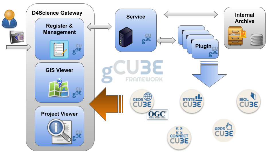
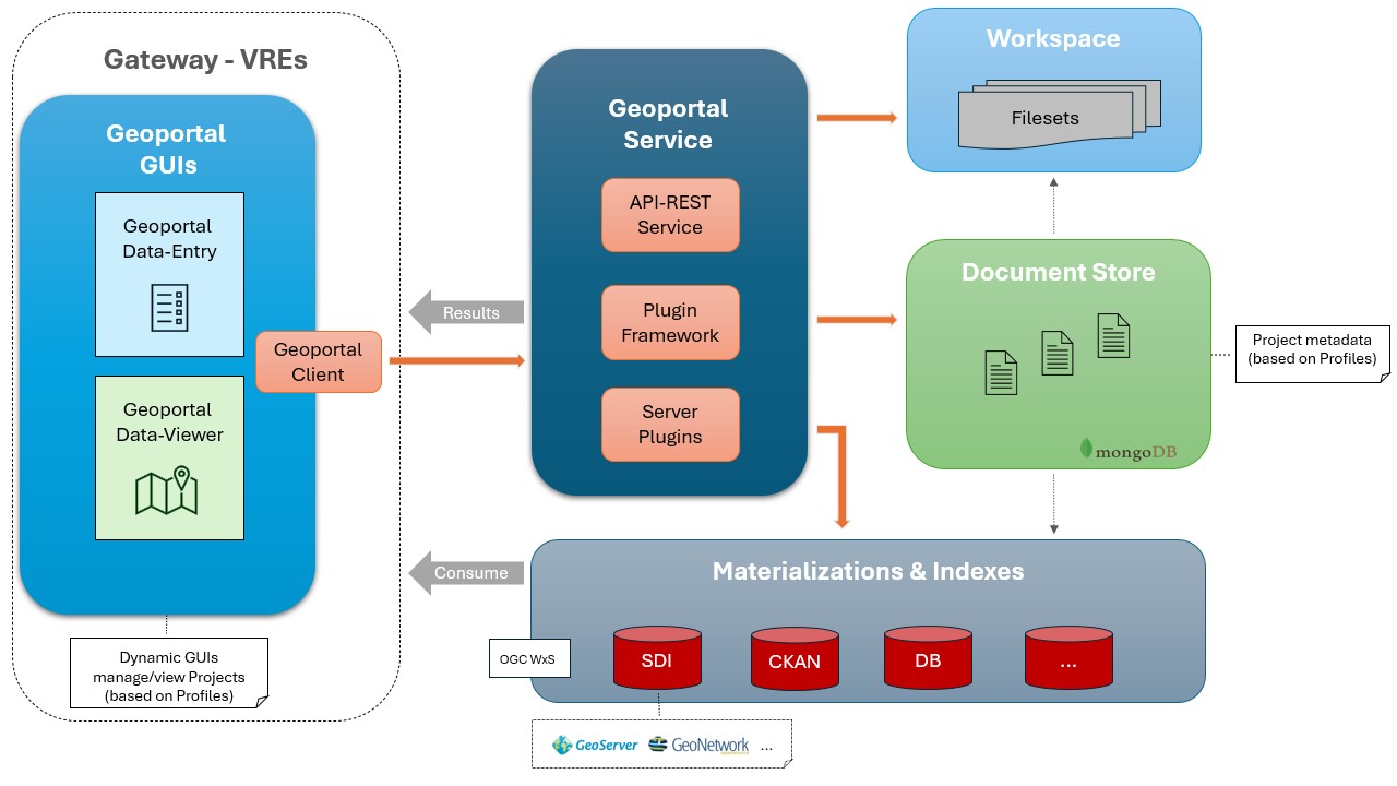
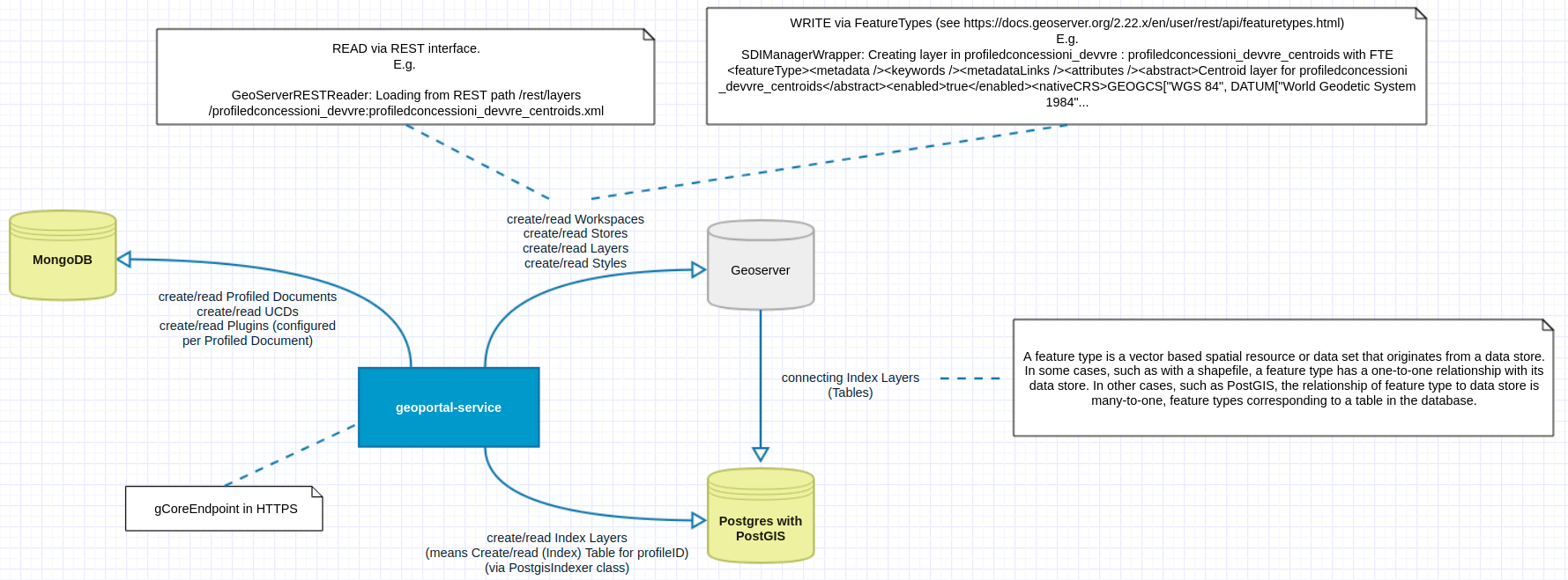
General Architecture
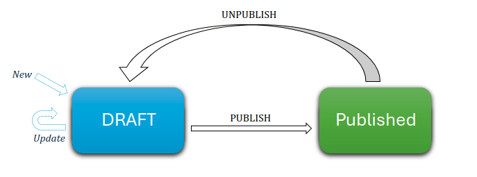
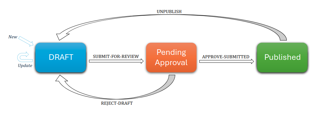
Lifecycle Managements
Document Lifecycle Managements in action:
Single Step (no moderation)
3 Phases (content moderation)
Plugins
Plugins in action:
Use Case
The D4GNA
"Dataset per il Geoportale Nazionale per l'Archeologia"
Component diagram:
Documentation
- Dedicated Wiki - powered by Sphynx
- Service Interactive API - powered by Enunciate
- Gcube System Wiki.
- Guide Notebooks - powered by Jupyter
Change log
See CHANGELOG.md.
Authors
-
Fabio Sinibaldi as "Architect", "Developer" (ORCID) Computer Scientist at ISTI-CNR
-
Francesco Mangiacrapa as "Architect", "Developer" and "Maintainer" (ORCID) Computer Scientist at ISTI-CNR Infrascience Group
License
This project is licensed under the EUPL V.1.1 License - see the LICENSE.md file for details.
About the gCube Framework
This software is part of the gCubeFramework: an open-source software toolkit used for building and operating Hybrid Data Infrastructures enabling the dynamic deployment of Virtual Research Environments by favouring the realisation of reuse oriented policies.
The projects leading to this software have received funding from a series of European Union programmes including:
- the Sixth Framework Programme for Research and Technological Development
- DILIGENT (grant no. 004260).
- the Seventh Framework Programme for research, technological development and demonstration
- D4Science (grant no. 212488);
- D4Science-II (grant no.239019);
- ENVRI (grant no. 283465);
- iMarine(grant no. 283644);
- EUBrazilOpenBio (grant no. 288754).
- the H2020 research and innovation programme
- SoBigData (grant no. 654024);
- PARTHENOS (grant no. 654119);
- EGIEngage (grant no. 654142);
- ENVRIplus (grant no. 654182);
- BlueBRIDGE (grant no. 675680);
- PerformFish (grant no. 727610);
- AGINFRAplus (grant no. 731001);
- DESIRA (grant no. 818194);
- ARIADNEplus (grant no. 823914);
- RISIS2 (grant no. 824091);