12 KiB
Spatial Search
The spatial extension allows to index datasets with spatial information so they can be filtered via a spatial search query. This includes both via the web interface (see the Spatial Search Widget) or via the action API, e.g.:
http://localhost:5000/api/action/package_search?q=Pollution&ext_bbox=-7.535093,49.208494,3.890688,57.372349The ext_bbox parameter must be provided in the form
ext_bbox={minx},{miny},{maxx},{maxy}
Setup
To enable the spatial search you need to add the
spatial_query plugin to your ini file. This plugin in turn
requires the spatial_metadata plugin, eg:
ckan.plugins = ... spatial_metadata spatial_queryTo define which backend to use for the spatial search use the following configuration option (see Choosing a backend for the spatial search):
ckanext.spatial.search_backend = solr-bboxGeo-Indexing your datasets
Regardless of the backend that you are using, in order to make a dataset searchable by location, it must have a the location information (a geometry), indexed in Solr. You can provide this information in two ways.
The spatial extra
field
The easiest way to get your geometries indexed is to use an extra
field named spatial. The value of this extra should be a
valid GeoJSON geometry, for
example:
{
  "type":"Polygon",
  "coordinates":[[[2.05827, 49.8625],[2.05827, 55.7447], [-6.41736, 55.7447], [-6.41736, 49.8625], [2.05827, 49.8625]]]
}
or:
{
  "type": "Point",
  "coordinates": [-3.145,53.078]
}
Every time a dataset is created, updated or deleted, the extension
will index the information stored in the spatial in Solr,
so it can be reflected on spatial searches.
If you already have datasets when you enable Spatial Search then you'll need to rebuild the search index.
Custom indexing logic
You might not want to use the spatial extra field.
Perhaps you don't want to store the geometries in the dataset metadata
but prefer to do so in a separate table, or you simply want to perform a
different processing on the geometries before indexing.
In this case you need to implement the
before_dataset_index() method of the IPackageController
interface:
def before_dataset_index(self, dataset_dict):

    # When using the default `solr-bbox` backend (based on bounding boxes), you need to
    # include the following fields in the returned dataset_dict:

    dataset_dict["minx"] = minx
    dataset_dict["maxx"] = maxx
    dataset_dict["miny"] = miny
    dataset_dict["maxy"] = maxy

    # When using the `solr-spatial-field` backend, you need to include the `spatial_geom`
    # field in the returned dataset_dict. This should be a valid geometry in WKT format.
    # Shapely can help you get the WKT representation of your gemetry if you have it in GeoJSON:

    shape = shapely.geometry.shape(geometry)
    wkt = shape.wkt

    dataset_dict["spatial_geom"] = wkt

    # Don't forget to actually return the dict!

    return dataset_dict
Some things to keep in mind:
Remember, you only need to provide one field, either
spatial_bboxorspatial_geom, depending on the backend chosen.All indexed geometries should fall within the -180, -90, 180, 90 bounds. If you have polygons crossing the antimeridian (i.e. with longituded lower than -180 or bigger than 180) you'll have to split them across the antimeridian.
Check the default implementation of
before_dataset_index()in ckanext/spatial/plugins/__init__.py for extra useful checks and validations.If you want to store the geometry in the
spatialfield but don't want to apply the default automatic indexing logic applied by ckanext-spatial just remove the field from the dict (this won't remove it from the dataset metadata, just from the indexed data):def before_dataset_search(self, dataset_dict): dataset_dict.pop("spatial", None) return dataset_dict
Choosing a backend for the spatial search
Ckanext-spatial uses Solr to power the spatial search. The current implementation is tested on Solr 8, which is the supported version, although it might work on previous Solr versions.
Note
The are official Docker
images for Solr that have all the configuration needed to perform
spatial searches (look for the ones with a -spatial
suffix). This is the easiest way to get started but if you need to
customize Solr yourself see below for the modifications needed.
There are different backends supported for the spatial search, it is important to understand their differences and the necessary setup required when choosing which one to use. To configure the search backend use the following configuration option:
ckanext.spatial.search_backend = solr-bbox | solr-spatial-fieldThe following table summarizes the different spatial search backends:
| Backend | Supported geometries indexed in Solr | Solr setup needed |
|---|---|---|
solr-bbox (default) |
Bounding Box, Polygon (extents only) | Custom fields |
solr-spatial-field |
Bounding Box, Point and Polygon | Custom field + JTS |
Note
The default solr-bbox search backend was previously
known as solr. Please update your configuration if using
this version as it will be removed in the future.
The solr-bbox backend is probably a good starting point.
Here are more details about the available options (again, you don't need
to modify Solr if you are using one of the spatially enabled official
Docker images):
solr-bbox-
This option always indexes just the extent of the provided geometries, whether if it's an actual bounding box or not. It supports spatial sorting of the returned results (based on the closeness of their bounding box to the query bounding box). It uses standard Solr float fields so you just need to add the following to your Solr schema:
<fields>
    <!-- ... -->
    <field name="minx" type="float" indexed="true" stored="true" />
    <field name="maxx" type="float" indexed="true" stored="true" />
    <field name="miny" type="float" indexed="true" stored="true" />
    <field name="maxy" type="float" indexed="true" stored="true" />
</fields>
solr-spatial-field-
This option uses the RPT Solr field, which allows to index points, rectangles and more complex geometries like polygons. This requires the install of the JTS library. See the linked Solr documentation for details on this. Note that it does not support spatial sorting of the returned results. You will need to add the following field type and field to your Solr schema file to enable it :
<types>
    <!-- ... -->
    <fieldType name="location_rpt"   class="solr.SpatialRecursivePrefixTreeFieldType"
        spatialContextFactory="JTS"
        autoIndex="true"
        validationRule="repairBuffer0"
        distErrPct="0.025"
        maxDistErr="0.001"
        distanceUnits="kilometers" />
</types>

<fields>
    <!-- ... -->
    <field name="spatial_geom" type="location_rpt" indexed="true" multiValued="true" />
</fields>
By default, the
solr-sptatial-fieldbackend uses the following query. This can be customized by setting theckanext.spatial.solr_queryconfiguration option, but note that all placeholders must be included:"{{!field f=spatial_geom}}Intersects(ENVELOPE({minx}, {maxx}, {maxy}, {miny}))"
Note
The old postgis search backend is no longer supported.
You should migrate to one of the other backends instead.
Spatial Search Widget

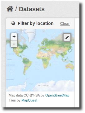
The extension provides a snippet to add a map widget to the search form, which allows filtering results by an area of interest.
To add the map widget to the sidebar of the search page, add the
following block to the dataset search page template
(myproj/ckanext/myproj/templates/package/search.html). If
your custom theme is simply extending the CKAN default theme, you will
need to add {% ckan_extends %} to the start of your custom
search.html, then continue with this:
{% block secondary_content %}

  {% snippet "spatial/snippets/spatial_query.html" %}

{% endblock %}
By default the map widget will show the whole world. If you want to
set up a different default extent, you can pass an extra
default_extent to the snippet, either with a pair of
coordinates like this:
{% snippet "spatial/snippets/spatial_query.html", default_extent="[[15.62,
    -139.21], [64.92, -61.87]]" %}
or with a GeoJSON object describing a bounding box (note the escaped quotes):
{% snippet "spatial/snippets/spatial_query.html", default_extent="{ \"type\":
    \"Polygon\", \"coordinates\": [[[74.89, 29.39],[74.89, 38.45], [60.50,
    38.45], [60.50, 29.39], [74.89, 29.39]]]}" %}
You need to load the spatial_metadata and
spatial_query plugins to use this snippet.
Dataset Extent Map

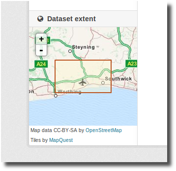
Using the snippets provided, if datasets contain a
spatial extra like the one described in the previous
section, a map will be shown on the dataset details page.
There are snippets already created to load the map on the left sidebar or in the main body of the dataset details page, but these can be easily modified to suit your project needs
To add a map to the sidebar, add the following block to the dataset
page template (eg
ckanext-myproj/ckanext/myproj/templates/package/read_base.html).
If your custom theme is simply extending the CKAN default theme, you
will need to add {% ckan_extends %} to the start of your
custom read.html, then continue with this:
{% block secondary_content %}
  {{ super() }}

  {% set dataset_extent = h.get_pkg_dict_extra(c.pkg_dict, 'spatial', '') %}
  {% if dataset_extent %}
    {% snippet "spatial/snippets/dataset_map_sidebar.html", extent=dataset_extent %}
  {% endif %}

{% endblock %}
For adding the map to the main body, add this to the main dataset
page template (eg
ckanext-myproj/ckanext/myproj/templates/package/read.html):
{% block primary_content_inner %}

  {{ super() }}

  {% set dataset_extent = h.get_pkg_dict_extra(c.pkg_dict, 'spatial', '') %}
  {% if dataset_extent %}
    {% snippet "spatial/snippets/dataset_map.html", extent=dataset_extent %}
  {% endif %}

{% endblock %}
You need to load the spatial_metadata plugin to use
these snippets.